Some of the lights along both banks of the river stand on what are here described as "Clyde Towers." The lantern itself and the solar cells and battery boxes are supported on a small framework, usually trapezoidal, which stands on a cylindrical drum maybe fifteen feet high, which is the characteristic mark of the design. The drum is bolted by four short legs to a concrete or wooden base, or occasionally to a lower drum. Access to the lantern is by an external ladder. Structures of this design appear only on the Clyde and (a few) in Loch Fyne. They are not really towers, but they are certainly not mere posts or poles. They receive M-numbers as towers, but they do not have separate thumbnail images. Most of the structures in this Section stand on industrial land to which there is no access; clearly there is no access to those on or under bridge girders, or to those on piles or masonry structures entirely within the river M119 is Ardencaple Castle near the end of Section J Dredged channel to Glasgow: North Bank Disused tower | ||
| M119-09-D A4482 114-0 |
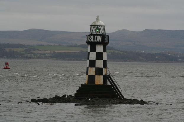
Cardross (was R 1/4, 12m, 6 miles) NS347752 |
Ruined red and white chequered pile beacon 15m no image available LR63; EX341N, 347; CH2007·1 |
Unlit tower but too good-looking to ignore! | ||
| -- | Leven Perch NS396742 |
Yellow and black masonry tower with unlit South Cardinal mark Stands on edge of shoal at entrance to River Leven Tower maybe 6m, post about 1m image LR63; EX341N, 347; CH2007·1 |
Clyde tower: | ||
| M120 A4490 114-4608 |
Dunglass R 1/2, 10m, 6 miles NS438735 |
Red Clyde Tower 11m image LR64; EX342, 347; CH2007·1 |
North Bank (continued) Onastic light: | ||
| M120-01 A4494 114-4612 |
Bowling West bkwr head R 1/4, 10m, 6 miles NS447735 |
Red metal column at end of ruined breakwater image LR64; EX342, 347; CH2007·1, CH2007·2 |
Clyde tower: | ||
| M121 A4496 114-4616 |
Donald's Quay R 1/4, 10m, 6 miles NS459730 (a few metres NW of its marked position on the OS map) |
Clyde Tower 11m: Red framework structure, narrow red drum, masonry base image LR64; EX342; CH2007·2 |
Erskine Bridge The navigable channel is marked by lanterns on brackets on the girders, all to the same design. The upper lantern is mounted on a bracket at road level, the lower one at the lower end of a six-foot post fixed to the same bracket and stayed to the lower chord of the girder. The towers also carry aero obstruction lights, which are not listed by Michael. The bridge is not recognised by Publ. 114 QY lights are occasionally shown from gantries inder the bridge "when maintenance work is taking place over the navigable channel." Girder-mounted lights: | ||
| M121-01 A4499·2 114-0 |
North-west face N end 2FR, 59m, 2 miles NS462724 |
lanterns on bracket no image available LR64; EX342; CH2007·2 |
| M121-02 A4499·3 114-0 |
North-west face S end 2FG, 59m, 2 miles NS462723 |
lanterns on short metal post image LR64; EX342; |
| M121-03 A4499·1 114-0 |
South-east face S end 2FG, 59m, 2 miles NS |
lanterns on short metal post image LR64; EX342; CH2007·2 |
| M121-04 A4499 114-0 |
South-east face N end 2FR, 59m, 2 miles NS |
lanterns on bracket no image available LR64; EX342; CH2007·2 |
North Bank (continued) Onastic lights: | ||
| M121-05 A4506 114-4640 |
Dalmuir West R 1/2, 10m, 6 miles NS477708 |
Red metal post, railed
balcony, on masonry base 11m image LR64; EX342; CH2007·2 |
Clyde Tower: | ||
| M122 A4510 114-4644 |
Dalmuir East R 1/4, 10m, 6 miles NS490703 |
Red Clyde Tower:
red framework structure on narrow red drum 11m image LR64; EX342; CH2007·2 |
Onastic light: | ||
| M122-01 A4511·2 114-4654 |
Slipway R 1/4, 5m, 3 miles NS497693 |
Red pile structure Rebuilding of riverside walls has caused this light to be relocated to a pile structure in the water. The slipway itself no longer exists image LR64; EX342; CH2007·2 |
Disused tower: | ||
| M123-D A4514 114-0 |
Yoker (was R 1/4, 5m, 3 miles) NS511685 |
Red Clyde Tower on masonry base: all that now remains is the base and the sawn-off support legs image LR64; EX342 |
Onastic light: | ||
| M123-01 A4514·3 114-0 |
Renfrew Ferry: N slipway 2FR, 4m, 2 miles NS512685 |
Galvanised metal post on end of disused pier 1m image LR64; EX342; CH2007·3 |
Science Centre The aero obstruction lights at the Science Centre are disregarded by Michael Onastic lights: | ||
| M123-02 A4526·5 114-0 |
West of Millennium Bridge R 1/4, 4m, 3 miles NS566653 |
Short metal post on red pile with red square topmark, ladder to water level 3m image The Admiralty gives this the same reference as M123-20 LR64; EX342; CH2007·4 |
| M123-03 A4527 114-4693 |
West of Bell's Bridge R 1/10, 3m, 1 mile NS568652 |
Pile with red square, no ladder 3m image LR64; EX342; CH2007·4 |
| M123-04 A4527 114-0 |
Bell's Bridge West face centre 3FR Traffic signals NS568652 |
Centre of bridge Marks centre of channel when bridge closed arranged as triangle point up image LR64; EX342; CH2007·4 |
| M123-05 A4527 114-0 |
Bell's Bridge East face centre 3FR Traffic signals NS568652 |
Centre of bridge marks centre of channel when bridge closed arranged as triangle point up image LR64; EX342; CH2007·4 |
| M123-06 A4527·4 114-4695 |
East of Bell's Bridge R 1/3, 3m, 3 miles NS568652 |
Pile with red square, no
ladder 3m image LR64; EX342; CH2007·4 |
Publication 114 recognises no lights above Bell's bridge Clyde Arc Bridge :The Admiralty references are duplicated for the E and W sides of the bridge Bridge-mounted lights: | ||
| M123-07 A4527·701 114-0 |
West face N end QR, 7m, 4 miles NS572650 |
Lantern on bracket alongside red square. Images: general view showing red and white markers detail LR64; EX342; CH2007·4 |
| M123-08 A4527 114-0 |
West face centre Long/10, 7m, 3 miles NS572650 |
Lantern on bracket alongside red circle with white stripes. Images: detail image In the general view as for M123-07, this item is hidden behind the striped marker LR64; EX342; CH2007·4 |
| M123-09 A4527·702 114-0 |
West face S end QG, 7m, 4 miles NS572650 |
Lantern on bracket alongside green triangle point up general view showing green and white markers LR64; EX342; CH2007·4 |
| M123-10 A4527·702 114-0 |
East face S end QG, 7m, 4 miles NS572650 |
Green triangle point up general view of upstream side LR64; EX342; CH2007·4 |
| M123-11 A4527 114-0 |
East face centre Long/10, 7m, 3 miles NS572650 |
Red circle with white stripes general view of upstream side Notice that on this side of the bridge, all the lights are mounted on that side of the marker that is closer to the girder LR64; EX342; CH2007·4 |
| M123-12 A4527·701 114-0 |
East face N end R 1/3, 3m, 3 miles NS572650 |
Red square general view of upstream side LR64; EX342; CH2007·4 |
Tradeston Footbridge :As for the Clyde Arc, the Admiralty references are duplicated for the E and W sides of the bridge Bridge-mounted lights: | ||
| M123-13 A4527·8 114-0 |
West face centre Long 1/10, 5m, 4 miles NS584648 |
Lantern slung below span image LR64; EX342; CH2007·4 |
| M123-14 A4527·8 114-0 |
East face centre Long 1/10, 5m, 4 miles NS584648 |
Lantern slung below span image Shown 24 hours, but this may be by accident LR64; EX342; CH2007·4 |
City Centre Onastic lights: | ||
| M123-15 A4528 114-0 |
Broomielaw Pontoon W 2FR, 5m NS584649 |
Metal post about 4m image LR64; EX342; CH2007·4 |
| M123-16 A4528·1 114-0 |
Broomielaw Pontoon E 2FR, 5m NS585649 |
Grey metal post about 4m image LR64; EX342; CH2007·4 |
| M123-17 A4529 114-0 |
Custom House Quay 2FR, 4m, 1 mile NS587648 |
Metal post 3m Unlit January 2009 image LR64; EX342; CH2007·4 |
South Bank Science Centre Onastic lights: | ||
| M123-18 A4527·6 114-4696 |
East of Bell's Bridge G 1/10, 3m, 3 miles NS568651 |
Pile with green triangle point up, no ladder 3m image general view of piles upstream of Bell's Bridge LR64; EX342; CH2007·4 |
| M123-19 A4527·2 114-4694 |
West of Bell's Bridge G 1/10, 3m, 3 miles NS568652 |
Pile with green triangle point up, no ladder 3m image LR64; EX342; CH2007·4 |
| M123-20 A4526·5 114-0 |
West of Millenium Bridge G 1/4, 4m, 3 miles NS566652 |
Short metal post on green pile, ladder to water level 3m image The Admiralty gives this the same reference as M123-02 Shown 24 hours LR64; EX342; CH2007·4 |
South Bank (continued) Onastic lights: | ||
| M123-21 A4521 114-4688 |
Fairfield G 1/5, 10m, 8 miles NS547663 |
Green post 11m image LR64; EX342; CH2007·3, ·4 |
| M123-22 A4520 114-4684 |
Linthouse G 1/5, 10m, 8 miles NS542663 |
Green metal post 11m (not framework structure as described by Admiralty) image image showing waterproofing device LR64; EX342; CH2007·3, ·4 |
| M123-23 A4519 114-4680 |
Shieldhall G 1/2, 17m, 8 miles (charted at) NS538664 |
Green mast 18m no image available (not found at dusk: an 18m mast with a green flashing light ought to be visible, so maybe destroyed) LR64; EX342; CH2007·3 |
Clyde tower: | ||
| M124 A4516 114-4672 |
Braehead G 1/2, 10m, 8 miles NS523673 |
Green Clyde Tower 11m image image showing seagull-deflectors on solar cells LR64; EX342; CH2007·3 |
Disused tower: | ||
| M125-D A4515 114-4668 |
Renfrew East (was 1/5, 10m, 8 miles) NS513682 |
Black column 11m
Discontinued later than 2000 no image available (may be destroyed) LR64; EX342 |
Onastic lights: | ||
| M125-01 A4514·4 114-0 |
Renfrew Ferry: S slipway 2FG, 4m, 2 miles NS510684 |
Grey post on dolphin 1m image LR64; EX342; CH2007·3 |
| M125-02 A4513 114-4660 |
Renfrew West G 1/5, 10m, 8 miles NS509686 |
Green post, railed balcony 11m image LR64; EX342; CH2007·3 |
Hybrid light: | ||
| M126 A4512 114-4656 |
Blythswood G 1/2, 10m, 8 miles NS499690 |
 Green round tower on green base 12m Green round tower on green base 12m
The only structure along the upper part of the river that looks like a lighthouse, but sadly now with the optic removed and replaced by an external lantern on the railing of the balcony LR64; EX342; CH2007·2, CH2007·3 |
Onastic lights: | ||
| M126-01 A4511 114-4652 |
Algie's G 1/5, 7m, 8 miles NS492697 |
Lantern supported on upper member of green metal portal frame (described by Admiralty as a gantry) 6m image LR64; EX342; CH2007·2 |
| M126-02 A4508 114-4648 |
Newshot G 1/5, 10m, 8 miles NS485704 |
Green trapezoidal framework on four piles Said to be 11m but looks much lower, perhaps only 5m image LR64; EX342; CH2007·2 |
Clyde Tower: | ||
| M127 A4504 114-4636 |
Rashielee G 1/2, 10m, 8 miles NS473708 |
Green Clyde Tower
on wooden framework base 11m image LR64; EX342; CH2007·2 |
Onastic light: | ||
| M127-01 A4501 114-4628 |
Erskine G 1/5, 10m, 8 miles NS467716 |
Green metal post on
concrete base 11m image LR64; EX342; CH2007·2 |
Clyde Tower: | ||
| M128 A4498 114-4620 |
St Patrick's Stone G 1/5, 10m, 8 miles NS461724 |
Green Clyde Tower
on masonry base 11m image LR64; EX342; CH2007·2 |
The south side (true left bank) of the dredged channel from just west of Bowling Harbour to the mouth of the River Leven is marked by a training wall on which stand a number of round masonry towers. It is not clear that any of these except M129 and M130 have ever been lit Clyde Tower: | ||
| M129 A4488 114-4604 |
Longhaugh G 1/2, 10m, 8 miles NS429732 |
Green Clyde Tower
on masonry base 11m image LR64; EX342, 347; CH2007·1 |
Tower light: | ||
| M130 A4486 114-4600 |
Dumbuck G 1/2, 10m, 8 miles NS413737 |
 Green round tower on green base 12m Green round tower on green base 12m
The thumbnail shows the tower from the south; the larger image is from the north-west, showing the lantern which is visible only from the dredged channel LR64; EX342, 347; CH2007·1 |
Clyde Tower: | ||
| M131 A4484 114-4596 |
Garrison G 1/5, 10m, 8 miles NS396739 |
Green Clyde Tower
on masonry base 11m image LR63; EX341N, 347; CH2007·1 |
Port Glasgow Tower lights: | ||
|
M132 A4476 114-4588 |
Perch FG, 7m, 9 miles NS322749 |
 Black and white chequered tower and cupola 8m Black and white chequered tower and cupola 8mShown 24 hours LR63; EX341N, EX347; CH2007·1 |
| M133 A4478 114-4592 |
Steamboat Quay FG, 12m, 12 miles NS320749 |
 Black and white chequered round tower 8m Black and white chequered round tower 8mShown 24 hours LR63; EX341N, 347; CH2007·1 |
|
M134 A4472 114-4584 |
Maurice Clark Point
QG, 7m, 2 miles NS3006755 |
 Green circular masonry tower 7m
with stepped masonry top and external ladder to weatherproof lantern Green circular masonry tower 7m
with stepped masonry top and external ladder to weatherproof lanternLR63; EX341N; CH1994, 1994·1, 2007·1 |
Greenock Onastic lights: | ||
| M134-01 A4470 114-4580 |
Garvel Embankment W G Oc/10, 9m, 4 miles NS299760 |
Post 2m image LR63; EX341N; CH1994, 1994·1 |
Greenock Disused onastic light: | ||
| >M134-02-D -- -- |
Garvel Basin discontinued after 1955 FR, G or Or, 17m, 3 miles NS292759 |
Lattice mast with railway-style signal image LR63; EX341N |
Greenock Onastic lights (continued): | ||
| M134-04 A4458 114-4572 |
Victoria harbour entrance W side 2FG, 7m, ? miles NS287760 |
Green post 5m image LR63; EX341N; CH1994 |
| M134-05 A4442·1 114-4568 |
Lts in line rear FG, 33m, ? miles NS274769 |
Pylon (very tall lattice mast) 80m Shown 24 hours images LR63; EX341N; CH1994 |
| M134-06 A4442 114-4564 |
Lts in line front FG, 18m, ? miles In line 194·5° NS275772 |
White mast c. 4m on roof of pilot building image LR63; EX341N; CH1994 |
| Onastic lights: | ||
| M134-07 A4444 114-4560 |
Container terminal NW corner QG, 8m, 8 miles NS275773 |
Grey square metal post image LR63; EX341N; CH1994, 2131 |
| M134-08 A4440 114-4556 |
Anchorage Limit: Lts in line rear FG, 9m, 12 miles NS266777 |
Yellow column 11m image Other images see M134-09 LR63; EX341N; CH1994, 2131 |
| M134-09 A4438 114-4552 |
Anchorage Limit: Lts in line front FG, 7m, 12 miles NS266778 |
Yellow fluted cast-iron column with black base and ornate capital 11m images LR63; EX341N; CH1994, 2131 |
| M134-10 A4416 114-0 |
Whiteforeland Point FRGG NS258779 |
White post about 4m on roof of Coastguard building Shown when Rhu Narrows closed image LR63; EX341N; CH1994 (no magenta flash), 3746 Discontinued after 2013: indications now shown by M117-25 in Section J |
Gourock Onastic lights: | ||
| M134-11 A4415 114-0 |
RoRo terminal 2FG, 9m, 5 miles NS244777 |
Metal post 5m on dolphin image LR63; EX341N, 363S; CH1994, 2131, 3746 |
| M134-12 A4414·5 114- |
Station light G 1/3, 4m, 3 miles NS244778 |
Metal post on concrete base 2m; marks S end of new embankment built 2010 when
station was modernised image LR63; EX341N, 363S |
| M134-13 A4414 114-4416 |
Kempock Point G 1/6, 11m, 3 miles NS242780 |
Metal post 4m image LR63; EX341N, 363S; CH1994, 2131, 3746 |
| M134-14 A4405·1 114-0 |
McInroy's Point NW RoRo terminal head QG, 7m, 2 miles NS219769 |
Grey metal post image LR63; EX341N; CH1994, 2131 3746 |
| M134-15 A4405 114-4396 |
McInroy's Point Root of old RoRo quay 2FG, 5m, 6 miles NS218768 |
Metal post image Shown 24 hours LR63; EX341N; CH1994 3746 |
| Hybrid light: | ||
| M135 A4404 114-4404 |
Cloch Point 1/3, 24m, 8 miles NS203759 |
 Established 1797 (John Clarkson, for Established 1797 (John Clarkson, for Cumbrae Lighthouse Trust; optics by Smith and Robert Stevenson) White round tower with black band and green domed copper cupola white dwellings 23m LR63; EX341N; CH1907, 1994, 2131 3746 |
Inverkip Onastic lights: | ||
| M135-01 A4393·2 114-0 |
Oil Jetty N 2FG, 11m, 2 miles NS190711 |
Dolphin no image available LR63; EX341N; CH1907, 2131 |
| M135-02 A4393 114-0 |
Oil Jetty S 2FG, 11m, 2 miles NS188707 |
Dolphin no image available LR63; EX341N; CH1907, 2131 |
Wemyss Bay Onastic lights: | ||
| M135-03 A4392 114-4392 |
Pier 2FG, 7m, 5 miles NS192685 |
Metal post 12m no image available LR63; EX341N; CH1907, 2131 |
Largs Onastic lights: | ||
| M135-04 A4360 114-4352 |
Pier N end 2FG, 7m, 5 miles NS200595 |
Metal post 5m no image available LR63; EX341N, S; CH1907, 2131, 2221, 2491 |
| M135-05 A4359·2 114-4350 |
Marina W breakwater head R Oc/10, 4m, 4 miles NS206570 |
Metal post with red square 2m no image available LR63; EX341S; CH1867·3, 1907, 2131, 2221, 2491 |
| M135-06 A4359 114-4349 |
Marina S breakwater head G Oc/10, 4m, 4 miles NS 205570 |
Metal post with green triangle point up 2m no image available LR63; EX341S; CH1867·3, 1907, 2131, 2221, 2491 |
Fairlie Onastic lights: | ||
| M135-07 A4358 114-0 |
Quay head 2FG NS205564 |
no image available LR63; EX341S; CH1867·3, ·4, 1907, 2131, 2221, 2491 |
| M135-08 A4358·2 114-0 |
Quay elbow 2FG NS205562 |
no image available LR63; EX341S; CH1867·3,·4, 1907, 2131, 2221, 2491 |
| M135-09 A4355 114- 4348.2 |
Hunterston Jetty NE end 2FG, 11m, 5 miles NS195550 |
Green metal post no image available LR63; EX341S; CH1867·3, ·5, 1907, 2131, 2221, 2491 |
| M135-10 A4355·2 114- 4348.4 |
Hunterston Jetty SW corner 2FG, 11m, 5 miles NS192547 |
Green metal post no image available LR63; EX341S; CH1867·3, ·5, 1907, 2131, 2221, 2491 |